Exhibition themes Porapora region+Keram River
The southern tributaries of the Porapora and Keram rivers feed into the Sepik River through expanses of swamps interspersed with sago trees, wild sugarcane and grasslands. During the wet season vast tracts of the region are immersed. As kiap JK McCarthy observed, the swamplands bordering the Keram River ensured that the indigenous communities rarely trod on dry ground, spending much of their lives in canoes or up to their thighs in mud.1 Much of this region is almost impassable and travel can only be undertaken during the wet season. Patrols by kiaps only penetrated this area from 1930 onwards.
The Porapora cultural area is situated between the Ramu and Keram rivers in the middle of these swamplands, with the Aion people to the north, nearer the Sepik, and the Adjirab people further south.2
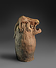
The Keram River is more accessible and was mapped by the German Kaiserin-Augusta-Fluss-Expedition between 1912 and 1913. It was named the Töpferfluss (Potter’s River, or Pottery River), but it is also possible that Keram comes from the German word keramisch for ceramics. Both indicate that pottery was a visible industry of the Kambot people, who occupy about 16 villages mainly along the banks of the Keram River. Their culture is similar in many respects to their neighbours yet the Kambot excelled in creating boards decorated with feathers and in the use of clay for mixed-media objects. Ceremonial houses were also visually distinctive for having a projecting roof over the entrance suggestive of an open crocodile’s mouth.
1 Jack Keith McCarthy, Patrol into yesterday: my New Guinea years, FW Cheshire Publishing Pty Ltd, Melbourne, 1963, p 65.
2 Josefine Huppertz, Mobul: the ancestor of the Kambot people in north-east New Guinea, Alano Verlag/Edition Herodot, 1992, pp 141–2 gives Adjiraab and Patricia May, Margaret Tuckson, The traditional pottery of Papua New Guinea, Crawford House, Bathurst, 2000 (1982), p 250 give Adjora.


![| Yunmi [fish charm] | 19th to early 20th century, prior to 1938](images/sml/243513.jpg)