

Curriculum links Geography
Peru is divided geographically into northern, central and southern regions: coast and highlands encompass deserts, river valleys, lush rainforests and steep mountains. In the south-east lies the Altiplano, the high plateau bordering Bolivia, which contains Lake Titicaca. The Andes Mountains run like an inland spine down the country, dividing the coastal regions from the Amazon Basin.
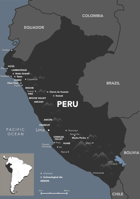
Peru is located on the western part of South America just below the equator and is an extremely diverse country with 11 ecological regions and 84 of the world’s 117 different types of ‘life zones’ or biogeographic regions. The variety of geography consists of a coastal plain in the west, high rugged mountains in its center (the Andes) and a lowland jungle in the east that leads into the Amazon River basin and provides Peru with a wide range of natural resources. The highest point in Peru is Nevado Huascaran at 22,205 feet (6,768 m).
Life in coastal Peru has been impacted for centuries by the periodic upheaval brought about by El Niño-Southern Oscillation (ENSO) events, environmental inversions that still affect the coast today. El Niño is a warm ocean current that runs along the Peruvian coast, pushing the Peru Current out to sea. El Niño causes extreme weather-related disturbances in South America, including drought, torrential rains, mudslides and avalanches.
There are strong links to the demise of certain cultures from the catastrophic floods from El Niño such the downfall of the Nazca culture with overflowing water unable to be absorbed in the deforested Ica Valley. The downfall of the Moche culture is linked to the disastrous consequences of a severe El Niño in the sixth century, which caused 30 years of flooding, then 30 years of drought. Another catastrophic El Niño affected the Chimú reliance on canal irrigation forcing them to expand militarily to become a state based on conquest and tribute.
The Humbolt Current, named after the Prussian naturalist Alexander von Humboldt is a cold ocean current of low salinity which flows north along the west coast of South America from the southern tip of Chile to northern Peru. Also called the Peru Current, it supports an extraordinary abundance of marine life which was a valuable life source for the people of Peru. The current also has a considerable cooling and drying influence on the climates of Peru and the surrounding regions.
Throughout Peru there are a number of natural World Heritage Sites, including the Historic Sanctuary of Machu Picchu. The desert regions of Peru are also home to the famous Nazca lines which have been etched in the ground between the Ingenio and Nazca river valleys. These drawings have been remarkably preserved because the Nazca is one of the driest and most windless regions on earth.
The Gold and the Incas: Lost worlds of Peru exhibition has strong links with a number of content descriptions across the year 8 and 10 bands of the Australian Curriculum: Geography. The cross curriculum priority of Sustainability also has links to this learning area and content. In general, students can focus on the aesthetic, cultural and spiritual value of the coastal desert, Andes ranges and Amazonian rainforest for people of the past as revealed by the exhibition.
The Gold and the Incas: Lost worlds of Peru secondary school online resource focuses on specialisations within the subject’s two strands:
- Geographical inquiry and skills strand
- Geographical knowledge and understanding strand
Year 8 geography
Geographical knowledge and understanding
The exhibition Gold and the Incas: Lost worlds of Peru has relevance to the Landforms and landscapes unit of study which focuses on investigating geomorphology through a study of landscapes and their landforms. This unit examines the processes that shape individual landforms, the values and meanings placed on landforms and landscapes by diverse cultures, hazards associated with landscapes, and management of landscapes. The Landforms and landscapes unit develops students’ understanding of the concept of environment and enables them to explore the significance of landscapes to people, including Aboriginal and Torres Strait Islander Peoples. These distinctive aspects of landforms and landscapes are investigated using studies drawn from Australia and throughout the world.
There are two content descriptions in Landforms and landscapes that have particular relevance for setting the works of art from Gold and the Incas in their landform and landscape context of coastal desert, high mountain ranges and rainforest.
- The different types of landscapes and their distinctive landform features (ACHGK048)
- The aesthetic, cultural and spiritual value of landscapes and landforms for people, including Aboriginal and Torres Strait Islander Peoples (ACHGK049)
Geographical inquiry and skills
There are a number of content descriptions in this strand that have relevance to the Gold and the Incas: Lost worlds of Peru exhibition.
- Develop geographically significant questions and plan an inquiry using appropriate geographical methodologies and concepts (ACHGS055)
- Collect, select and record relevant geographical data and information, using ethical protocols, from appropriate primary and secondary sources (ACHGS056)
- Evaluate sources for their reliability and usefulness and represent data in a range of appropriate forms (ACHGS057)
- Represent the spatial distribution of different types of geographical phenomena by constructing appropriate maps at different scales (ACHGS058)
- Analyse geographical data and other information using qualitative and quantitative methods, and digital and spatial technologies, to identify and propose explanations for spatial distributions, patterns and trends and infer relationships (ACHGS059)
- Apply geographical concepts to draw conclusions based on the analysis of the data and information collected (ACHGS060)
- Present findings, arguments and ideas in a range of communication forms selected to suit a particular audience and purpose, using geographical terminology and digital technologies (ACHGS061)
Key questions:
- How do environmental and human processes affect the characteristics of places and environments?
- How do the interconnections between places, people and environments affect the lives of people?
- What are the consequences of changes to places and environments and how can these changes be managed?
Year 10 geography
Geographical knowledge and understanding
The exhibition can be related to the Environmental change and management study which focuses on investigating environmental geography through an in-depth study of a specific environment.
Environmental change and management requires schools/students to select one of the following types of environment as the context for study: land, inland water, coast, marine or urban. A comparative study of examples selected from Australia and at least one other country should be included.
One content description from this unit of study is relevant to Gold and the Incas when dealing with the Peruvian coast or marine environments:
- The environmental worldviews of people and their implications for environmental management (ACHGK071)
Geographical inquiry and skills
There are a number of content descriptions in this strand that have relevance to the Gold and the Incas: Lost worlds of Peru exhibition:
- Develop geographically significant questions and plan an inquiry that identifies and applies appropriate geographical methodologies and concepts (ACHGS072)
- Collect, select, record and organise relevant data and geographical information, using ethical protocols, from a range of appropriate primary and secondary sources (ACHGS073)
- Evaluate sources for their reliability, bias and usefulness and represent multi-variable data in a range of appropriate forms (ACHGS074)
- Represent the spatial distribution of geographical phenomena by constructing special purpose maps that conform to cartographic conventions, using spatial technologies as appropriate (ACHGS075)
- Evaluate multi-variable data and other geographical information using qualitative and quantitative methods and digital and spatial technologies to make generalisations and inferences, propose explanations for patterns, trends, relationships and anomalies, and predict outcomes (ACHGS076)
- Apply geographical concepts to synthesise information from various sources and draw conclusions based on the analysis of data and information, taking into account alternative points of view (ACHGS077)
- Identify how geographical information systems (GIS) might be used to analyse geographical data and make predictions (ACHGS078)
- Present findings, arguments and explanations in a range of appropriate communication forms selected for their effectiveness and to suit audience and purpose (ACHGS079)
Key question:
- How do worldviews influence decisions on how to manage environmental and social change?
There are a range of questions for year 8 students to explore related to environmental and human processes and how they affect the characteristics of places and environments; the interconnections between places, people and environments affect the lives of people and; the consequences of changes to places and environments and how can these are managed. In doing this students can select two to three of the following:
- Investigate how the Andes were formed and the reasons for the coastal desert.
- Map the spatial distribution of the civilisations featured in the exhibition and their location within the major landscapes and their features
- Consider what the exhibition reveals about what such landscapes provide in terms of food, fibre and means of transport
- Explore how the Humboldt Current and El Niño Southern Oscillation impact on Peru and why access to the resources of the ocean area important
- Map the spatial distribution of the cultures featured in the exhibition and their connection with the sea and east-west fresh water flows
- Investigate what is involved in large-scale irrigation solutions to water distribution and scarcity.
- Explore what environmental worldview can be deduced from the art works in the exhibition. Consider this in relation to the importance of cyclicality and interconnectedness.
- Consider does the broad type of worldview seen in the exhibition continue among the Andean cultures in South America today?
- Investigate how the Andean worldview expressed in contemporary Peruvian society. What elements have remained strongest and which have the least impact now?


